 |
| http://images.chinahighlights.com/chinamap/ancient/ming-dynasty-map1.gif |
 |
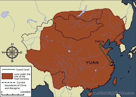
| http://images.chinahighlights.com/chinamap/ancient/map-yuan-dynasty-full.gif |
This is a map of the Ming dynasty (1368-1644). The red shows the land that the Ming dynasty ruled. The blue doted lines are the locations of the Great Wall. The black doted lines are the boundaries of current day China and Mongolia. The rest of the light blue lines are rivers. The little green dot is the capital Beijing. The Ming expanded into many other countries like Southeast Asia and the Ryukyu Islands and goes beyond present day China's boarders. The dynasty before the Ming was the Yuan dynasty (1271-1368). The Yuan expanded beyond the current boarders of China in all directions. As you can see the the Ming is a lot smaller compared to the Yuan.
No comments:
Post a Comment